

Near the center of the many Marius Hills, recently surmised to be many vents of a single source volcano that China's Chang'e-1 investigators have unofficially named Yutu, the scene above is at the heart of the complex of many small domes, each with a very low profile. These domes are familiar landmarks to earthbound observers, easily visible in modest telescopes only when the sunrise (or sunset) terminator sweeps over Oceanus Procellarum three days before a Full Moon. Within hours these hills, only slightly darker than the surrounding terrain, disappear in the glare. The Sun was less than 2° above the eastern horizon when LRO flew 45 km overhead, during orbit 2329, December 28, 2009, and Arizona State University's LROC Wide-Angle Camera swept up this exposure (M116683214ME) [NASA/GSFC/Arizona State University].

By way of comparison, here (yet again) is a portion of Lunar Orbiter V-152 that shows much the same area seen at the crack of dawn in the LROC WAC frame up above, but in a middle to late morning sun four decades ago. The two tallest of the squat domes or their many neighbors are hardly distinguishable. The twin rilles between them were, however, well out of the shadows. The southern and longer of these channels hosts the "Marius Hole" (or Haruyama Skylight), identified by Japan's Kaguya (SELENE-1) investigators in 2008, near the elbow of it's upper-most bend [NASA/JPL/USGS/LPI]..
We've written and reported a lot about the Marius Hills Volcanic Complex, If there been an Apollo 18 Marius Hills might have been the landing site. Alas, those missions were scrubbed and their architectures were cannibalized for the Skylab and Apollo-Soyuz missions (and the Smithsonian).
Since we're on the subject, even though it's been posted here before in the context of Lunar studies published in connection with the Lunar and Planetary Science Conference in March (seem like only yesterday), a whole "slew" of professional investigators published LROC OBSERVATIONS OF THE MARIUS HILLS in connection with that event.
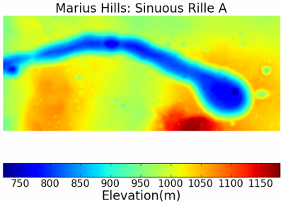
Clearly, were not paying as close attention as necessary. Originally, in this post, we speculated briefly on why Marius did not appear among the fifty Constellation Regions of Interest, when we knew better. Checking back with our sources, as we thought had, the area around Sinuous Rille A (below, 13.58°N, 304.2°) is definitely listed among those Tier 2 Constellation ROI's.
Coincidentally, you have to get up pretty early in the morning to keep up with the professionals shepherding the Lunar Reconnaissance Orbiter Camera. LROC's Samuel Lawrence posted a very interesting (and timely!) discussion of the Marius ROI date June 1.
We've written and reported a lot about the Marius Hills Volcanic Complex, If there been an Apollo 18 Marius Hills might have been the landing site. Alas, those missions were scrubbed and their architectures were cannibalized for the Skylab and Apollo-Soyuz missions (and the Smithsonian).
Since we're on the subject, even though it's been posted here before in the context of Lunar studies published in connection with the Lunar and Planetary Science Conference in March (seem like only yesterday), a whole "slew" of professional investigators published LROC OBSERVATIONS OF THE MARIUS HILLS in connection with that event.
Clearly, were not paying as close attention as necessary. Originally, in this post, we speculated briefly on why Marius did not appear among the fifty Constellation Regions of Interest, when we knew better. Checking back with our sources, as we thought had, the area around Sinuous Rille A (below, 13.58°N, 304.2°) is definitely listed among those Tier 2 Constellation ROI's.
Coincidentally, you have to get up pretty early in the morning to keep up with the professionals shepherding the Lunar Reconnaissance Orbiter Camera. LROC's Samuel Lawrence posted a very interesting (and timely!) discussion of the Marius ROI date June 1.
 |
| From 41st Lunar & Planetary Science Conference (2010) |
Figure 3 from "LROC OBSERVATIONS OF THE MARIUS HILLS," 41st Lunar and Planetary Science Conference (2010): LROC Digital Terrain Model (DTM), Sinuous Rille A in the Marius Hills.
No comments:
Post a Comment